Big Island, Hawaii
Author: Andreas Paul
2 July 2025
The Hawaiian Hotspot
The island chain of Hawaii is located in the center of the Pacific Ocean, to the north of the equator. It formed through the continuous movement of the pacific oceanic plate over a so-called Volcanic Hotspot, over millions of years (Figure 1).

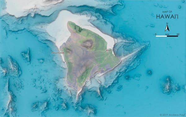
The volcanic activity left traces not only at the surface but also deep under the ocean, as shown by the map in Figure 2. The map shows the Big Island of Hawaii in its center and submarine features which normally would be hidden from view surrounding it.
Many of these features are the direct result of volcanic activity, or were produced by landslides related to volcanic eruptions or earthquakes. North-south trending structures visible to the west of the island may specifically be related to volcanism at fault systems that accompany this expansive island chain.
Map Details
The map was created using QGIS, Blender3D, and Affinity Photo. It uses a bathymetry & topography grid provided by The University of Hawaii at Manoa with a resolution of 50 m. Gaps in this data were filled with lower resolution data GEBCO 2019 grid.
The satellite image of Big Island was created by Tom Patterson as part of a tutorial on Landsat 8 imagery, and is available on Shadedrelief.com. Data for roads and populated places comes from NaturalEarthData.com.